Why it matters
What it tends to unlock
Perception, mapping, detection, and safer motion decisions, cleaner autonomy loops when the robot needs environmental context, and higher-quality data for navigation, manipulation, or monitoring.
3d Mapping And Smart Navigation appears across 1 tracked robots, concentrated in Cleaning. Use this page to understand why the signal matters, who relies on it most, and which live profiles deserve the first comparison click.
Tracked robots
1
Ready now
1
Manufacturers
1
Public prices
1
Why it matters
Perception, mapping, detection, and safer motion decisions, cleaner autonomy loops when the robot needs environmental context, and higher-quality data for navigation, manipulation, or monitoring.
What to verify
Coverage, placement, and how the sensor performs in messy conditions, what decisions actually rely on the sensor versus backup systems, and whether the label signals depth, proximity, or full-scene understanding.
Coverage
The heaviest concentration is in Cleaning (1). Top manufacturers include WYBOT (1).
Research brief
The useful questions here are how common 3d Mapping And Smart Navigation really is, which robot classes depend on it, and which live profiles are worth opening before you compare the whole stack.
Verified 30d
1
1 in the last 90 days
Top category
Cleaning
1 tracked robots
Paired most often with
36 Integrated Sensors, AI vision debris detection with first-run 3D mapping, smart route planning, targeted spot cleaning, and real-time positioning, and AI Vision System
Decision brief
Where it helps most
What to validate
Evidence basis
Source pack
Use the structure first: which categories lean on 3d Mapping And Smart Navigation, which manufacturers repeat it, and what usually ships beside it.
Lead category
1 tracked robots currently anchor this label.
Most repeated manufacturer
1 tracked robots make this the clearest manufacturer-level signal on the route.
Most common adjacent signal
1 shared robots pair this component with 36 Integrated Sensors.
| # | Name | Usage |
|---|---|---|
| 1 | Cleaning | 1 robot |
| # | Name | Usage |
|---|---|---|
| 1 | WYBOT | 1 robot |
| # | Name | Shared robots |
|---|---|---|
| 1 | 36 Integrated Sensors | 1 robot |
| 2 | AI vision debris detection with first-run 3D mapping, smart route planning, targeted spot cleaning, and real-time positioning | 1 robot |
| 3 | AI Vision System | 1 robot |
| 4 | Cloud Connectivity | 1 robot |
| 5 | Mobile App | 1 robot |
How to read the market
Category concentration tells you where the component is actually doing work, manufacturer repetition shows whether the signal is market-wide or vendor-specific, and pairings reveal which neighboring technologies usually ship alongside it.
The old card wall is replaced with a featured first-click strip and a dense inventory table so the route behaves like a serious directory.
Directory briefing
Open the clearest profiles first, then sweep the full inventory in a denser table. Featured cards are selected by readiness, image quality, and official source availability, so the first click is usually the most informative one.
Ready now
1
Public price
1
Official links
1
Featured now
1
How to scan this directory
Best first clicks
These robots score highest on readiness, public detail quality, and image clarity, making them the fastest way to understand how 3d Mapping And Smart Navigation shows up in practice.
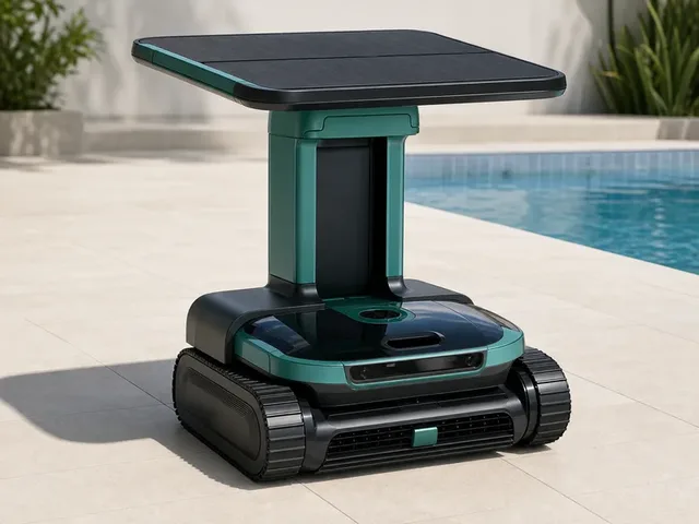
WYBOT's S3 is a premium cordless robotic pool cleaner for outdoor in-ground pools. Official WYBOT materials position it as a flagship model with first-run 3D pool mapping, AI-guided debris detection, real-time app positioning, and an Omni Dock that automatically handles docking, charging, and debris transfer into a 10L shore-side bin. WYBOT says the S3 can clean pool floors, walls, and waterlines for up to 180 minutes per cycle, with solar and DC dock charging designed to reduce hands-on maintenance. Active in the catalog with enough detail to review immediately.
Compact mobile scan: status, price, standout context, and links stay visible without sideways scrolling.
WYBOT · Cleaning
Price
$2,500
Standout
Battery · Up to 180 minutes per cleaning cycle
Quick answers
The short version of what this label means in the ui44 catalog, where it matters, and how to compare it without over-reading the marketing copy.
3d Mapping And Smart Navigation currently appears on 1 tracked robots across 1 manufacturers. That makes this route useful for both deep research and fast shortlist scanning, not just one-off editorial reading.
The strongest concentration is in Cleaning (1). Category mix is the fastest clue for whether this component behaves like baseline plumbing or a more selective differentiator.
1 of the 1 tracked profiles are currently marked Available or Active. That means the label has live market relevance here, but you should still open the profiles with public pricing or official links first before treating it as a clean buyer signal.
Start with readiness, official source quality, and the standout spec column in the inventory table. On component routes, those three signals usually remove weak profiles faster than reading every descriptive paragraph.
The strongest shared-stack signals here are 36 Integrated Sensors (1), AI vision debris detection with first-run 3D mapping, smart route planning, targeted spot cleaning, and real-time positioning (1), and AI Vision System (1). Use those pairings to branch into adjacent component pages when one label is too narrow for the decision.
1 matching robots currently expose public pricing. That is enough to create directional context, but not enough to treat one price bracket as the whole market. Use the directory to find the transparent profiles first, then widen the sweep.
Start with WYBOT (1). Repetition across manufacturers is often the clearest signal that the component is part of a stable market pattern rather than a one-off marketing callout.
The original long-form component research is still here, but collapsed so the main route can prioritize hierarchy and scan speed.
The baseline explanation of what 3d Mapping And Smart Navigation is, why it matters, and how to think about it before comparing implementations.
3d Mapping And Smart Navigation is a sensor component found in 1 robot tracked in the ui44 Home Robot Database. As a sensor technology, 3d Mapping And Smart Navigation plays a specific role in enabling robot perception, interaction, or operation depending on its implementation in each platform.
Sensors are the perceptual backbone of any robot. They convert physical phenomena — light, sound, distance, motion, temperature — into digital signals that the robot's AI can process and act upon.
In the ui44 database, 3d Mapping And Smart Navigation is categorized under Sensor components. For a comprehensive explanation of all component types, consult the components glossary.
The sensor suite is one of the most important differentiators between robots. Robots with richer sensor arrays can navigate more complex environments, avoid obstacles more reliably, and perform more nuanced tasks.
Directly impacts what a robot can actually do in practice — not just on paper
Richer sensor arrays enable more complex navigation and interaction
Determines obstacle avoidance reliability and object/person recognition
Used in 1 robot across 1 category — Cleaning, indicating specialized use across the robotics industry.
Modern robot sensors work by emitting or detecting various forms of energy. The robot's processor fuses data from multiple sensors simultaneously (sensor fusion) to build a coherent understanding of its surroundings.
Active sensors
LiDAR and ultrasonic emit signals and measure reflections to determine distance and shape
Passive sensors
Cameras and microphones detect ambient light and sound without emitting anything
Sensor fusion
The processor combines data from all sensors simultaneously for a coherent environmental picture
3d Mapping And Smart Navigation Integration
Implementation varies by robot platform and manufacturer. Each robot integrates 3d Mapping And Smart Navigation differently depending on system architecture, use case, and target tasks. Integration with other onboard sensors and the main processing unit determines real-world performance.
Deeper technical framing, matched technology profiles, and the longer use-case treatment for 3d Mapping And Smart Navigation.
In-depth technical analysis of 1 technology domain relevant to this component
While the sections above cover general sensor principles, this analysis focuses on the particular technology domains relevant to 3d Mapping And Smart Navigation based on its implementation characteristics.
Depth sensors extend robot perception into three dimensions, enabling the detection of objects at varying heights — critical for avoiding furniture legs, detecting items on the floor, and navigating around pets and children. While traditional 2D LiDAR scans at a single horizontal plane, depth sensors provide distance measurements across a two-dimensional field of view, creating a depth map that reveals the 3D structure of the scene.
Several technologies enable depth sensing in robots. Structured light projection casts a known pattern (typically infrared dots or stripes) onto the scene and analyzes the pattern's deformation to calculate distances — the same principle used in early Microsoft Kinect sensors and modern smartphone face scanners. Stereo depth cameras use two horizontally offset cameras (mimicking human binocular vision) and compute depth from the disparity between the two images. Active stereo systems combine stereo cameras with an infrared projector that adds texture to featureless surfaces, improving depth accuracy in environments with plain walls or smooth floors. Time-of-flight depth cameras emit modulated infrared light across their entire field of view and measure the phase shift of the reflected light to determine distance at each pixel simultaneously.
The choice of depth sensing technology involves significant engineering trade-offs. Structured light works well indoors but fails in direct sunlight. Stereo depth cameras have minimum distance limitations and can struggle with textureless surfaces. Time-of-flight sensors offer the best outdoor performance but may have lower resolution than structured light alternatives. For home robots, the operating environment is relatively controlled — consistent indoor lighting, defined room boundaries, and predictable surface types — which allows manufacturers to optimize their depth sensing approach for this specific context rather than requiring the most universal (and expensive) solution.
In the ui44 database, 3d Mapping And Smart Navigation is currently tracked exclusively in the S3 by WYBOT. This cleaning robot integrates 3d Mapping And Smart Navigation as part of a total technology stack comprising 6 components: 3 sensors, 2 connectivity modules, and a AI vision debris detection with first-run 3D mapping, smart route planning, targeted spot cleaning, and real-time positioning AI platform.
WYBOT's S3 is a premium cordless robotic pool cleaner for outdoor in-ground pools. Official WYBOT materials position it as a flagship model with first-run 3D pool mapping, AI-guided debris detection, real-time app positioning, and an Omni Dock that automatically handles docking, charging, and debris transfer into a 10L shore-side bin. WYBOT says the S3 can clean pool floors, walls, and waterlines …
The S3 is priced at $2,500, which includes 3d Mapping And Smart Navigation as part of the integrated sensor package. Visit the full S3 specification page for complete technical details and purchasing information.
3d Mapping And Smart Navigation works alongside 2 other sensor components in the S3: 36 integrated sensors, AI vision system. This combination of sensor technologies creates the S3's overall sensor capabilities, with each component contributing different aspects of environmental perception.
Beyond the high-level overview, understanding the technical foundations of sensor technologies like 3d Mapping And Smart Navigation helps buyers and researchers evaluate implementations more critically.
Every sensor converts a physical quantity into an electrical signal that can be digitized and processed. The raw analog output is conditioned through amplification, filtering, and A/D conversion before reaching the processor.
Sensor performance involves key metrics with inherent engineering trade-offs.
Sensor technology in robotics has evolved dramatically over the past decade.
Early home robots relied on simple bump sensors and infrared proximity detectors
Today's platforms incorporate multi-spectral cameras, solid-state LiDAR, and millimeter-wave radar
Miniaturization: sensors that filled circuit boards now fit into fingernail-sized packages
Next frontier: sensor fusion at the hardware level — multiple sensing modalities in single chip-scale packages
No sensor is perfect in all conditions. Understanding limitations is critical for evaluating robots in specific environments.
Key application domains for sensor technologies like 3d Mapping And Smart Navigation.
Sensors enable robots to build maps of their environment, detect obstacles in real time, and plan collision-free paths. This is essential for both indoor robots (navigating furniture and doorways) and outdoor robots (handling terrain variations and weather conditions). The quality and coverage of the sensor array directly determines how reliably a robot can navigate without human intervention.
Advanced sensors allow robots to identify objects by shape, color, and texture, enabling tasks like picking up items, sorting packages, or recognizing faces. Depth-sensing technologies are particularly important for calculating object distances and sizes, which is necessary for precise manipulation in both home and industrial settings.
In environments shared with humans, sensors provide the critical safety layer that prevents robots from causing harm. Proximity sensors, bumper sensors, and vision systems work together to detect people and obstacles, triggering immediate stop or avoidance maneuvers. This is a fundamental requirement for any robot operating in homes, hospitals, or public spaces.
Sensors can measure temperature, humidity, air quality, and other environmental parameters. Robots equipped with these sensors can perform automated monitoring rounds in warehouses, data centers, or homes, alerting users to abnormal conditions like water leaks, temperature spikes, or poor air quality.
Microphones, cameras, and touch sensors enable natural interaction between robots and humans. These sensors allow robots to recognize voice commands, detect gestures, respond to touch, and maintain appropriate social distances during conversations or collaborative tasks.
Visit each robot's detail page to see which capabilities are available on specific models.
Manufacturer mix, specs context, price context, category overlap, and adjacent components worth branching into next.
3d Mapping And Smart Navigation spans 1 robot category — from consumer to research platforms.
Technologies most often paired with 3d Mapping And Smart Navigation across 1 robot.
Browse the full components directory or see the components glossary for detailed explanations of each technology.
1 of 1 robots with 3d Mapping And Smart Navigation have public pricing, ranging $2.5k – $2.5k.
Lowest
$2.5k
S3
Average
$2.5k
1 robot with pricing
Highest
$2.5k
S3
1106 other sensor technologies tracked in ui44, ranked by adoption.
39 robots
22 robots
16 robots
16 robots
14 robots
13 robots
12 robots
12 robots
Browse all Sensor components or use the robot comparison tool to evaluate how different sensor configurations perform across specific robot models.
The robotics sensor market is one of the fastest-growing segments in the broader sensor industry. As robots move from controlled industrial environments into unstructured home and commercial spaces, the demands on sensor technology increase dramatically.
Multi-modal sensing
Robots combine multiple sensor types (vision, depth, tactile, inertial) to build comprehensive environmental understanding
Miniaturization
Sensors that once occupied entire circuit boards now fit into fingernail-sized packages, making advanced sensing affordable for consumer robots
Edge AI integration
AI processing directly in sensor modules enables faster perception without cloud latency
Industry Adoption Snapshot
3d Mapping And Smart Navigation is adopted by 1 robot from 1 manufacturer in the ui44 database, providing a data-driven view of real-world deployment patterns.
Certifications carried by robots incorporating 3d Mapping And Smart Navigation, indicating compliance with safety, EMC, and quality standards.
Platform compatibility, voice integration, and AI capabilities across robots with 3d Mapping And Smart Navigation.
The long-form buyer, maintenance, and troubleshooting material kept available without forcing it into the main scan path.
If 3d Mapping And Smart Navigation is an important factor in your robot selection, here are key considerations to guide your decision.
Coverage area
Does the sensor array provide 360° awareness or only forward-facing detection?
Range
How far can the robot sense obstacles or objects?
Resolution
How detailed is the sensor data for recognition tasks?
Redundancy
Are there backup sensors if one fails?
Serviceability
Are sensors user-serviceable or require manufacturer maintenance?
A component is only as good as its integration. Check how the manufacturer has incorporated 3d Mapping And Smart Navigation into the overall robot design and software stack.
Review what other sensor technologies are paired with 3d Mapping And Smart Navigation in each robot — see the related components section.
Make sure the robot's category matches your use case. 3d Mapping And Smart Navigation serves different roles in different robot types.
Consider the manufacturer's reputation for software updates, support, and component reliability.
Compare Before You Buy
Use the ui44 comparison tool to evaluate robots with 3d Mapping And Smart Navigation side by side.
Sensors are among the most maintenance-sensitive components in a robot. Their performance can degrade over time due to physical wear, environmental exposure, and calibration drift. Understanding the maintenance profile of a robot's sensor suite helps set realistic expectations for long-term ownership and operation.
Sensor durability varies significantly by type. Solid-state sensors like IMUs and accelerometers have no moving parts and typically last the lifetime of the robot.
Regular sensor maintenance primarily involves keeping optical surfaces clean. Camera lenses, LiDAR windows, and infrared emitters should be wiped with a soft, lint-free cloth to remove dust and fingerprints.
When evaluating sensor technology for long-term value, consider the manufacturer's track record for software updates that improve sensor utilization. A robot with good sensors and ongoing software development can actually improve its performance over time as algorithms are refined.
For the 1 robot in the ui44 database using 3d Mapping And Smart Navigation, we recommend checking the individual robot pages for manufacturer-specific maintenance guidance and support documentation. Each manufacturer has different support policies, update frequencies, and warranty terms that affect the long-term ownership experience of their sensor technologies.
Sensor-related issues are among the most common problems home robot owners encounter. Many sensor issues can be resolved with simple maintenance or environmental adjustments, while others may indicate hardware problems requiring manufacturer support. Understanding common failure modes helps you diagnose and resolve issues quickly, minimizing robot downtime.
Likely Causes
Resolution
Likely Causes
Resolution
Likely Causes
Resolution
For model-specific troubleshooting, visit the individual robot pages for the 1 robot using 3d Mapping And Smart Navigation. Each manufacturer provides model-specific support resources and diagnostic tools for their sensor implementations.
What to do next
This page should hand you off to the next useful comparison step, not strand you at the bottom of a long detail route.
Widen the layer
Open the full sensor workbench when 3d Mapping And Smart Navigation is only one part of the decision and you need the broader market map.
Side-by-side check
Move from label-level research into direct robot comparison once you know which profiles are documented well enough to trust.
Adjacent signal
This is the most common neighboring component on robots that already use 3d Mapping And Smart Navigation, so it is the fastest next branch if you need stack context.
