Why it matters
What it tends to unlock
Higher-level planning, adaptation, and interaction quality, richer autonomy claims that can change the shortlist materially, and more flexible task handling when the vendor stack is mature enough.
360° LiDAR plus dual-vision navigation with centimeter-level positioning, autonomous mapping, and AI obstacle detection for 1,000+ obstacle types appears across 1 tracked robots, concentrated in Lawn & Garden. Use this page to understand why the signal matters, who relies on it most, and which live profiles deserve the first comparison click.
Tracked robots
1
Ready now
0
Manufacturers
1
Public prices
1
Why it matters
Higher-level planning, adaptation, and interaction quality, richer autonomy claims that can change the shortlist materially, and more flexible task handling when the vendor stack is mature enough.
What to verify
What runs on-device versus in the cloud, how branded AI labels map to real user-facing behavior, and whether updates and latency tradeoffs fit the intended job.
Coverage
The heaviest concentration is in Lawn & Garden (1). Top manufacturers include ANTHBOT (1).
Research brief
The useful questions here are how common 360° LiDAR plus dual-vision navigation with centimeter-level positioning, autonomous mapping, and AI obstacle detection for 1,000+ obstacle types really is, which robot classes depend on it, and which live profiles are worth opening before you compare the whole stack.
Verified 30d
0
0 in the last 90 days
Top category
Lawn & Garden
1 tracked robots
Paired most often with
360° rotating LiDAR, Bag Fullness Radar Sensor, and Dual Hdr Wide-angle Cameras
Decision brief
Where it helps most
What to validate
Evidence basis
Source pack
Use the structure first: which categories lean on 360° LiDAR plus dual-vision navigation with centimeter-level positioning, autonomous mapping, and AI obstacle detection for 1,000+ obstacle types, which manufacturers repeat it, and what usually ships beside it.
Lead category
1 tracked robots currently anchor this label.
Most repeated manufacturer
1 tracked robots make this the clearest manufacturer-level signal on the route.
Most common adjacent signal
1 shared robots pair this component with 360° rotating LiDAR.
| # | Name | Usage |
|---|---|---|
| 1 | Lawn & Garden | 1 robot |
| # | Name | Usage |
|---|---|---|
| 1 | ANTHBOT | 1 robot |
| # | Name | Shared robots |
|---|---|---|
| 1 | 360° rotating LiDAR | 1 robot |
| 2 | Bag Fullness Radar Sensor | 1 robot |
| 3 | Dual Hdr Wide-angle Cameras | 1 robot |
| 4 | Optional 4g Service | 1 robot |
| 5 | Rain Sensor | 1 robot |
How to read the market
Category concentration tells you where the component is actually doing work, manufacturer repetition shows whether the signal is market-wide or vendor-specific, and pairings reveal which neighboring technologies usually ship alongside it.
The old card wall is replaced with a featured first-click strip and a dense inventory table so the route behaves like a serious directory.
Directory briefing
Open the clearest profiles first, then sweep the full inventory in a denser table. Featured cards are selected by readiness, image quality, and official source availability, so the first click is usually the most informative one.
Ready now
0
Public price
1
Official links
1
Featured now
1
How to scan this directory
Best first clicks
These robots score highest on readiness, public detail quality, and image clarity, making them the fastest way to understand how 360° LiDAR plus dual-vision navigation with centimeter-level positioning, autonomous mapping, and AI obstacle detection for 1,000+ obstacle types shows up in practice.
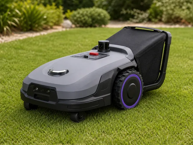
ANTHBOT N8 LiDAR is a 2026 residential robotic lawn mower for larger fenced gardens that stands out by doing more than routine wire-free mowing. Official ANTHBOT materials position it as a 4-in-1 lawn-care robot that can mow, mulch, collect clippings, and sweep leaves, using a 23-liter auto-dumping bin instead of leaving everything on the grass. The LiDAR variant pairs 360° LiDAR with dual-vision sensing for centimeter-level navigation without a boundary wire or RTK base station, making it a stronger fit for enclosed or obstacle-dense yards than many conventional premium mowers. Independent CES coverage also corroborates that the N8 LiDAR is the premium collection-focused model in ANTHBOT's new N series lineup. Commercial intent is clear, but delivery timing should be validated.
Compact mobile scan: status, price, standout context, and links stay visible without sideways scrolling.
ANTHBOT · Lawn & Garden
Price
$1,399
Standout
Battery · 70 min per charge with bag attached
Quick answers
The short version of what this label means in the ui44 catalog, where it matters, and how to compare it without over-reading the marketing copy.
360° LiDAR plus dual-vision navigation with centimeter-level positioning, autonomous mapping, and AI obstacle detection for 1,000+ obstacle types currently appears on 1 tracked robots across 1 manufacturers. That makes this route useful for both deep research and fast shortlist scanning, not just one-off editorial reading.
The strongest concentration is in Lawn & Garden (1). Category mix is the fastest clue for whether this component behaves like baseline plumbing or a more selective differentiator.
0 of the 1 tracked profiles are currently marked Available or Active. That means the label has live market relevance here, but you should still open the profiles with public pricing or official links first before treating it as a clean buyer signal.
Start with readiness, official source quality, and the standout spec column in the inventory table. On component routes, those three signals usually remove weak profiles faster than reading every descriptive paragraph.
The strongest shared-stack signals here are 360° rotating LiDAR (1), Bag Fullness Radar Sensor (1), and Dual Hdr Wide-angle Cameras (1). Use those pairings to branch into adjacent component pages when one label is too narrow for the decision.
1 matching robots currently expose public pricing. That is enough to create directional context, but not enough to treat one price bracket as the whole market. Use the directory to find the transparent profiles first, then widen the sweep.
Start with ANTHBOT (1). Repetition across manufacturers is often the clearest signal that the component is part of a stable market pattern rather than a one-off marketing callout.
The original long-form component research is still here, but collapsed so the main route can prioritize hierarchy and scan speed.
The baseline explanation of what 360° LiDAR plus dual-vision navigation with centimeter-level positioning, autonomous mapping, and AI obstacle detection for 1,000+ obstacle types is, why it matters, and how to think about it before comparing implementations.
360° LiDAR plus dual-vision navigation with centimeter-level positioning, autonomous mapping, and AI obstacle detection for 1,000+ obstacle types is a ai component found in 1 robot tracked in the ui44 Home Robot Database. As a ai technology, 360° LiDAR plus dual-vision navigation with centimeter-level positioning, autonomous mapping, and AI obstacle detection for 1,000+ obstacle types plays a specific role in enabling robot perception, interaction, or operation depending on its implementation in each platform.
The AI platform is the cognitive engine of a robot. It encompasses the machine learning models, decision-making algorithms, and processing infrastructure that enable a robot to interpret sensor data, plan actions, and interact naturally with humans.
In the ui44 database, 360° LiDAR plus dual-vision navigation with centimeter-level positioning, autonomous mapping, and AI obstacle detection for 1,000+ obstacle types is categorized under AI components. For a comprehensive explanation of all component types, consult the components glossary.
The AI platform fundamentally determines a robot's intelligence, adaptability, and user experience. The AI stack also affects responsiveness, privacy, and the robot's ability to receive meaningful software updates.
Advanced AI handles unexpected situations and improves over time
Enables natural language understanding for voice commands
On-device vs. cloud processing affects both privacy and capability
Used in 1 robot across 1 category — Lawn & Garden, indicating specialized use across the robotics industry.
Robot AI systems typically combine several layers that work together to transform raw data into intelligent behavior. Modern robots increasingly use neural networks with some processing on-device and some in the cloud.
Perception AI
Converts raw sensor data into understanding — recognizing objects, faces, and spaces
Planning AI
Decides what actions to take based on current understanding and goals
Control AI
Executes planned movements with precision, managing motors and actuators
Interaction AI
Understands and generates human communication — voice, gestures, text
360° LiDAR plus dual-vision navigation with centimeter-level positioning, autonomous mapping, and AI obstacle detection for 1,000+ obstacle types Integration
Implementation varies by robot platform and manufacturer. Each robot integrates 360° LiDAR plus dual-vision navigation with centimeter-level positioning, autonomous mapping, and AI obstacle detection for 1,000+ obstacle types differently depending on system architecture, use case, and target tasks. Integration with other onboard AI subsystems and the main processing unit determines real-world performance.
Deeper technical framing, matched technology profiles, and the longer use-case treatment for 360° LiDAR plus dual-vision navigation with centimeter-level positioning, autonomous mapping, and AI obstacle detection for 1,000+ obstacle types.
In-depth technical analysis of 1 technology domain relevant to this component
While the sections above cover general ai principles, this analysis focuses on the particular technology domains relevant to 360° LiDAR plus dual-vision navigation with centimeter-level positioning, autonomous mapping, and AI obstacle detection for 1,000+ obstacle types based on its implementation characteristics.
Simultaneous Localization and Mapping (SLAM) is the AI backbone of autonomous robot navigation. SLAM algorithms solve the chicken-and-egg problem of needing a map to determine the robot's position, while simultaneously needing to know the position to build the map. By processing continuous sensor data — from LiDAR, cameras, wheel encoders, and IMUs — SLAM algorithms construct and continuously refine an environmental map while tracking the robot's position within it.
Modern robot SLAM implementations use graph-based optimization, where the map is represented as a graph of sensor observations and spatial relationships that are jointly optimized to minimize overall error. Visual SLAM (vSLAM) uses camera imagery, identifying and tracking visual features like corners, edges, and textures. LiDAR SLAM uses point cloud matching to determine the robot's displacement between scans. Multi-sensor SLAM fuses both visual and geometric data for more robust localization. The choice of SLAM approach affects the robot's mapping accuracy, computational requirements, and resilience to challenging environments.
Path planning algorithms build on the SLAM-generated map to compute efficient, collision-free routes from the robot's current position to its destination. These range from classical graph search algorithms (A*, Dijkstra) that find optimal paths on grid maps, to sampling-based planners (RRT, PRM) that handle complex high-dimensional planning problems, to learned planners that use reinforcement learning to discover navigation strategies from experience. Dynamic obstacle avoidance layers handle moving people, pets, and objects that were not present in the stored map, combining real-time sensor data with predictive models of how obstacles might move.
In the ui44 database, 360° LiDAR plus dual-vision navigation with centimeter-level positioning, autonomous mapping, and AI obstacle detection for 1,000+ obstacle types is currently tracked exclusively in the N8 LiDAR by ANTHBOT. This lawn & garden robot integrates 360° LiDAR plus dual-vision navigation with centimeter-level positioning, autonomous mapping, and AI obstacle detection for 1,000+ obstacle types as part of a total technology stack comprising 6 components: 4 sensors, 1 connectivity module, and a 360° LiDAR plus dual-vision navigation with centimeter-level positioning, autonomous mapping, and AI obstacle detection for 1,000+ obstacle types AI platform.
ANTHBOT N8 LiDAR is a 2026 residential robotic lawn mower for larger fenced gardens that stands out by doing more than routine wire-free mowing. Official ANTHBOT materials position it as a 4-in-1 lawn-care robot that can mow, mulch, collect clippings, and sweep leaves, using a 23-liter auto-dumping bin instead of leaving everything on the grass. The LiDAR variant pairs 360° LiDAR with dual-vision …
The N8 LiDAR is priced at $1,399, which includes 360° LiDAR plus dual-vision navigation with centimeter-level positioning, autonomous mapping, and AI obstacle detection for 1,000+ obstacle types as part of the integrated ai package. Visit the full N8 LiDAR specification page for complete technical details and purchasing information.
Beyond the high-level overview, understanding the technical foundations of ai technologies like 360° LiDAR plus dual-vision navigation with centimeter-level positioning, autonomous mapping, and AI obstacle detection for 1,000+ obstacle types helps buyers and researchers evaluate implementations more critically.
Robot AI systems are built on layers of computational models, each handling different aspects of intelligence.
AI performance trade-offs — the accuracy-latency-energy triangle — fundamentally shape design decisions.
The AI landscape in robotics has undergone several paradigm shifts.
Classical robotics: hand-crafted rules and explicit programming
Machine learning era: data-driven approaches — learning from examples
Deep learning: end-to-end systems learning directly from raw sensor data
Foundation models & LLMs: broad world knowledge and natural language understanding
Current frontier: embodied AI — models that understand physics and spatial reasoning
Current robot AI has significant limitations that buyers should understand.
Key application domains for ai technologies like 360° LiDAR plus dual-vision navigation with centimeter-level positioning, autonomous mapping, and AI obstacle detection for 1,000+ obstacle types.
AI enables robots to make decisions in real time without human input. Whether it's choosing the optimal cleaning path, deciding when to return to the charging dock, or determining how to respond to an unexpected obstacle, the AI platform processes sensor data and selects the best course of action from its learned repertoire.
Modern AI platforms, especially those leveraging large language models, allow robots to understand and respond to conversational commands. This goes beyond simple keyword recognition — advanced AI can handle ambiguous requests, follow multi-step instructions, and maintain context across a conversation.
Some AI platforms allow robots to improve their performance over time by learning from experience. A robot might learn the most efficient cleaning route for your specific home, adapt to your daily routines, or improve its object recognition based on items it encounters repeatedly.
AI can monitor the robot's own systems, predicting when components might fail or need maintenance. By analyzing patterns in motor performance, battery degradation, and sensor accuracy, AI-equipped robots can alert users to potential issues before they cause problems.
AI platforms enable sophisticated task planning — breaking complex goals into executable steps, scheduling activities around user preferences, and re-planning when circumstances change. This capability is essential for robots that handle multiple responsibilities or operate on complex schedules.
Visit each robot's detail page to see which capabilities are available on specific models.
Manufacturer mix, specs context, price context, category overlap, and adjacent components worth branching into next.
360° LiDAR plus dual-vision navigation with centimeter-level positioning, autonomous mapping, and AI obstacle detection for 1,000+ obstacle types spans 1 robot category — from consumer to research platforms.
Technologies most often paired with 360° LiDAR plus dual-vision navigation with centimeter-level positioning, autonomous mapping, and AI obstacle detection for 1,000+ obstacle types across 1 robot.
Browse the full components directory or see the components glossary for detailed explanations of each technology.
1 of 1 robots with 360° LiDAR plus dual-vision navigation with centimeter-level positioning, autonomous mapping, and AI obstacle detection for 1,000+ obstacle types have public pricing, ranging $1.4k – $1.4k.
Lowest
$1.4k
N8 LiDAR
Average
$1.4k
1 robot with pricing
Highest
$1.4k
N8 LiDAR
407 other ai technologies tracked in ui44, ranked by adoption.
2 robots
1 robot
1 robot
1 robot
1 robot
1 robot
1 robot
1 robot
Browse all AI components or use the robot comparison tool to evaluate how different ai configurations perform across specific robot models.
The AI landscape in robotics is undergoing a transformation driven by advances in large language models, multimodal AI, and embodied intelligence research.
Foundation models for robotics
Purpose-built models that understand physics, spatial reasoning, and manipulation — enabling generalization to new tasks
On-device vs. cloud debate
Privacy-conscious buyers prefer local processing; cloud-connected robots benefit from more powerful, frequently updated models
Open-source frameworks
ROS 2 and PyTorch for robotics are lowering barriers, enabling more manufacturers to develop capable AI platforms
Industry Adoption Snapshot
360° LiDAR plus dual-vision navigation with centimeter-level positioning, autonomous mapping, and AI obstacle detection for 1,000+ obstacle types is adopted by 1 robot from 1 manufacturer in the ui44 database, providing a data-driven view of real-world deployment patterns.
Certifications carried by robots incorporating 360° LiDAR plus dual-vision navigation with centimeter-level positioning, autonomous mapping, and AI obstacle detection for 1,000+ obstacle types, indicating compliance with safety, EMC, and quality standards.
Platform compatibility, voice integration, and AI capabilities across robots with 360° LiDAR plus dual-vision navigation with centimeter-level positioning, autonomous mapping, and AI obstacle detection for 1,000+ obstacle types.
The long-form buyer, maintenance, and troubleshooting material kept available without forcing it into the main scan path.
If 360° LiDAR plus dual-vision navigation with centimeter-level positioning, autonomous mapping, and AI obstacle detection for 1,000+ obstacle types is an important factor in your robot selection, here are key considerations to guide your decision.
On-device vs. cloud
On-device AI works without internet but may be less powerful
Learning capability
Can the robot improve and adapt to your specific home over time?
Natural language
How well does it understand conversational voice commands?
Update frequency
Does the manufacturer regularly ship AI improvements?
Privacy
What data is sent to the cloud, and how is it protected?
Currently, none of the robots with 360° LiDAR plus dual-vision navigation with centimeter-level positioning, autonomous mapping, and AI obstacle detection for 1,000+ obstacle types are listed as directly available for purchase. They are in pre-order status. Monitor the individual robot pages for updates.
A component is only as good as its integration. Check how the manufacturer has incorporated 360° LiDAR plus dual-vision navigation with centimeter-level positioning, autonomous mapping, and AI obstacle detection for 1,000+ obstacle types into the overall robot design and software stack.
Review what other ai technologies are paired with 360° LiDAR plus dual-vision navigation with centimeter-level positioning, autonomous mapping, and AI obstacle detection for 1,000+ obstacle types in each robot — see the related components section.
Make sure the robot's category matches your use case. 360° LiDAR plus dual-vision navigation with centimeter-level positioning, autonomous mapping, and AI obstacle detection for 1,000+ obstacle types serves different roles in different robot types.
Consider the manufacturer's reputation for software updates, support, and component reliability.
Compare Before You Buy
Use the ui44 comparison tool to evaluate robots with 360° LiDAR plus dual-vision navigation with centimeter-level positioning, autonomous mapping, and AI obstacle detection for 1,000+ obstacle types side by side.
AI components present a unique maintenance profile because much of their capability is defined by software rather than hardware. This means AI performance can improve through updates but is also vulnerable to degradation if cloud services are discontinued or software support ends. Understanding the AI maintenance model is critical for assessing a robot's long-term value proposition.
The hardware that runs AI workloads — processors, memory, and neural network accelerators — is highly durable solid-state electronics. Physical failure of AI processing hardware is rare under normal operating conditions.
AI maintenance primarily involves keeping the robot's software stack updated. Firmware updates often include improved AI models, bug fixes for edge cases in perception or navigation, and new capabilities unlocked by algorithmic improvements.
AI future-proofing depends heavily on the manufacturer's ongoing investment in software development and the robot's computational headroom. Robots designed with more processing power than initially needed have room to run improved AI models in future updates.
For the 1 robot in the ui44 database using 360° LiDAR plus dual-vision navigation with centimeter-level positioning, autonomous mapping, and AI obstacle detection for 1,000+ obstacle types, we recommend checking the individual robot pages for manufacturer-specific maintenance guidance and support documentation. Each manufacturer has different support policies, update frequencies, and warranty terms that affect the long-term ownership experience of their ai technologies.
AI-related issues in robots often manifest as degraded performance rather than complete failures. The robot may navigate less efficiently, misrecognize objects, respond slowly to commands, or make decisions that seem illogical. Diagnosing AI issues requires understanding whether the problem is in the AI software, the input data feeding the AI, or the processing hardware running the AI models.
Likely Causes
Resolution
Likely Causes
Resolution
Likely Causes
Resolution
For model-specific troubleshooting, visit the individual robot pages for the 1 robot using 360° LiDAR plus dual-vision navigation with centimeter-level positioning, autonomous mapping, and AI obstacle detection for 1,000+ obstacle types. Each manufacturer provides model-specific support resources and diagnostic tools for their ai implementations.
What to do next
This page should hand you off to the next useful comparison step, not strand you at the bottom of a long detail route.
Widen the layer
Open the full ai workbench when 360° LiDAR plus dual-vision navigation with centimeter-level positioning, autonomous mapping, and AI obstacle detection for 1,000+ obstacle types is only one part of the decision and you need the broader market map.
Side-by-side check
Move from label-level research into direct robot comparison once you know which profiles are documented well enough to trust.
Adjacent signal
This is the most common neighboring component on robots that already use 360° LiDAR plus dual-vision navigation with centimeter-level positioning, autonomous mapping, and AI obstacle detection for 1,000+ obstacle types, so it is the fastest next branch if you need stack context.
